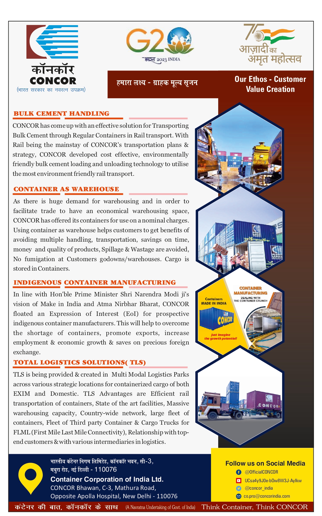
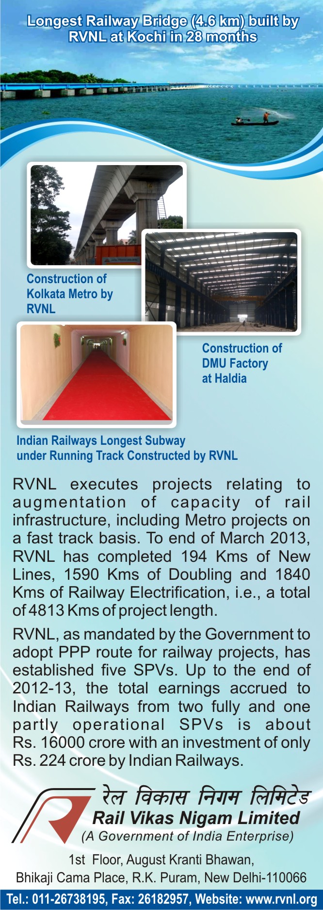
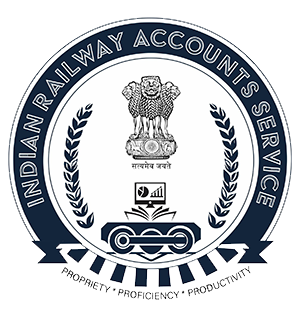
 The new IRAS Logo assimilates the past, present and future to demonstrate the future ready IRAS which upholds the principles of “Propriety, Proficiency and Productivity”.
The logo has been carefully designed to demonstrate the nature of the service and contemporary times.
Adorned with the National Emblem, the logo symbolizes service to the Government of India. The Railway bogie resting on the track symbolizes that IRAS is dedicated to serving the Indian Railways, the three wheels represents evolution and motion, and upholding the motto of “Propriety, Proficiency and Productivity”. The book and the computer monitor symbolizes that IRAS is the fusion of both old and new methods of analysis, its ability to continuously evolve and embrace innovations, bridging the traditional methods of accounting and book-keeping with latest technology such as data analysis, AI etc. to propel IR to an upward growth trajectory.
Finally the 25 pairs of leaves on the logo represents the 17 Zonal Railways and 8 Production units which comprise India Railways. They also symbolizes wisdom, prosperity, motion and continuity.
The logo is a demonstration of the “FUTURE READY IRAS”.
Conceptualised and designed by Shri. Puneet Meena, Shri. Ajay Bartwal and Shri. Rajat Agarwal
The new IRAS Logo assimilates the past, present and future to demonstrate the future ready IRAS which upholds the principles of “Propriety, Proficiency and Productivity”.
The logo has been carefully designed to demonstrate the nature of the service and contemporary times.
Adorned with the National Emblem, the logo symbolizes service to the Government of India. The Railway bogie resting on the track symbolizes that IRAS is dedicated to serving the Indian Railways, the three wheels represents evolution and motion, and upholding the motto of “Propriety, Proficiency and Productivity”. The book and the computer monitor symbolizes that IRAS is the fusion of both old and new methods of analysis, its ability to continuously evolve and embrace innovations, bridging the traditional methods of accounting and book-keeping with latest technology such as data analysis, AI etc. to propel IR to an upward growth trajectory.
Finally the 25 pairs of leaves on the logo represents the 17 Zonal Railways and 8 Production units which comprise India Railways. They also symbolizes wisdom, prosperity, motion and continuity.
The logo is a demonstration of the “FUTURE READY IRAS”.
Conceptualised and designed by Shri. Puneet Meena, Shri. Ajay Bartwal and Shri. Rajat Agarwal
Tuesday, May 21, 2024


Holiday Homes
| Location | PATNITOP |
| Railway Zone | RCF/KXG |
| Contact Person | DY.GM(G)/RCF KAPURTHALA |
| Address | DY.GM(G)/RCF KAPURTHALA PH:- 01822-228194 |
| No. Of Suites | 4 |
| Comment | Patnitop or Patni Top is a hilltop tourist location in Udhampur district in Jammu and Kashmir state of India on National Highway 1A 112 km from Jammu on the way from Udhampur to Srinagar. Situated on a plateau in the Shiwalik belt of the Himalayas, Patnitop sits at an altitude of 2,024 m (6,640 ft). The river Chenab flows in close proximity to this location. Snowfall and avalanche in winter at Patnitop obstructs National Highway 1A a few times every winter and causes long queues of vehicles - sometimes for days at length. India's longest road tunnel, the 9.2 km long Chenani-Nashri Tunnel or Patnitop Tunnel is being constructed starting from about 2 km from Chenani town south of Patnitop to Nashri village north of Patnitop to reduce the distance from Jammu to Srinagar and reduce traffic jams on NH-1A that occur due to snowfall and avalanche in winter at Patnitop. The Southern portal of the tunnel is at 33.0463°N 75.2793°E and the Northern portal of the tunnel is at coordinates 33.1285°N 75.2928°E. When the tunnel is completed, the highway will no longer pass through Patnitop. The tunnel will reduce the length of the highway by 31 km and the highway will bypass Patnitop. About 2 km of the tunnel had been excavated by April 2012 and about 50% of the length had been excavated by January 2013 |
| Phone No. | 01822-228194 |
Back To Review
Please Login to Provide Your Innovative idea / Professional issue . If You are not a member of IRASTIMES.ORG then Click Here to Signup.
x